


Sea Level Rise is Natural and the Sea Was Higher During the Time of Caesar Than Now!

Is sea level rising due to man-made climate change, as climate cultists keep insisting? Well, it depends, of course, on what period one is measuring and where the measurements are taking place. A post at No Tricks Zone earlier this week illustrates. It’s titled “Africa’s Atlantic Coast Sea Levels Were Still 1 Meter Higher Than Today 2000 Years Ago,” which tells us most of what we need to know, but here are a few additional observations:
The narrative that says relative sea level changes are driven by variations in atmospheric CO2 concentrations has taken another hit.
Before relative sea level (RSL) declined to its present position over the last millennium, Africa’s Atlantic coast RSL ranged anywhere from 0.8 to 4 meters higher than today between 5000 and 1700 years ago (Vacchi et al., 2025).
This Mid- to Late-Holocene RSL highstand was “mainly controlled by the deglaciation history” − meltwater contributions from Earth’s ice sheets and glaciers. Because the climate was so much warmer than today at that time, there was significantly less water locked up on land as ice.
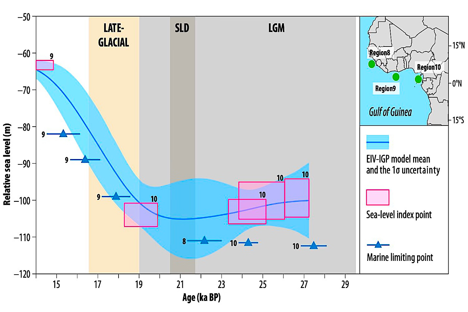
The study itself, linked above, is an example of how not to write if you want anyone other than fellow nerd academics to read or grasp what you’re saying, but it does include this nice graphic, which is fairly comprehensible:
As the chart shows, sea level over the last two millennia have gone down, a point almost never mentioned by climate change propagandists. Rises over the last few centuries reflect glacial retreats, but they’re nowhere near where things were at the time of Caesar.
Pondering how I might summarize the particulars and the implications of the study, I decided to give Grok a shot at it, and this is what I got:
The article “Sea level since the Last Glacial Maximum from the Atlantic coast of Africa,” published in Nature Communications in 2025, explores how sea levels along Africa’s Atlantic coast have changed over the past 30,000 years. By studying 347 carefully selected data points from places like Guinea Conakry and Cameroon, the researchers pieced together a timeline of sea-level changes and connected these shifts to past climate changes….
Here’s a summary in simple terms, aimed at a general audience.
About 30,000 years ago, Earth was in the grip of the Last Glacial Maximum (LGM), a period when massive ice sheets covered large parts of the Northern Hemisphere. These ice sheets locked up so much water that sea levels were much lower than they are today—about 99 to 104 meters (325 to 341 feet) below current levels along Africa’s Atlantic coast.
The study shows that during this cold period, from roughly 26,700 to 19,100 years ago, sea levels dropped gradually as more water was frozen into ice. Imagine the ocean pulling back, exposing more of the continental shelf, like a beach stretching out much farther than it does now.
As the planet began to warm around 15,000 years ago, the ice sheets started melting, and sea levels began to rise.
This rise wasn’t steady—it happened in bursts. At times, the sea level rose as fast as 25 millimeters per year (about an inch), which is incredibly rapid compared to today’s average rise of about 3-4 millimeters per year. Picture a coastline where the water creeps up noticeably year after year, flooding areas that were once dry. By around 8,000 years ago, this rapid rise slowed down significantly.
The researchers suggest this slowdown happened because the major ice sheets had mostly melted, so less water was being added to the oceans.
One of the most interesting findings comes from the mid to late Holocene, a period starting about 7,000 years ago. During this time, sea levels along Africa’s Atlantic coast didn’t just stabilize—they actually rose slightly above today’s levels, creating what’s called a “sea-level highstand.”
This means that in some areas, the sea was 0.8 to 4 meters (2.6 to 13 feet) higher than it is now.
This highstand varied by location and time, peaking between 5,000 and 1,700 years ago. Imagine coastal villages or ecosystems that existed back then having to adapt to higher water levels, with tides reaching farther inland than they do today.
The study also compares its findings to computer models that simulate how Earth’s crust and sea levels respond to the weight of ice and water—a process called glacial isostatic adjustment (GIA). These models predict how the land rises or sinks as ice melts or forms, affecting local sea levels.
However, the researchers found that the models didn’t perfectly match the real-world data, especially for the highstand. This mismatch suggests that the models might not fully account for how different ice sheets (like those in North America or Antarctica) contributed meltwater or how the land itself moved in response to changing weights of ice and water.
It’s like trying to solve a puzzle but finding that some pieces don’t fit quite right, hinting that we need to refine our understanding of these processes…
The study shows that sea-level changes aren’t uniform—they vary by region due to factors like land movement and ocean currents. Along Africa’s Atlantic coast, which includes wide, flat continental shelves, these variations are especially pronounced. For coastal communities in countries like Guinea Conakry or Cameroon, knowing how sea levels might rise in the future is crucial for planning things like infrastructure, agriculture, or flood defenses.
The researchers also highlight that their data fills a gap, as most sea-level studies focus on other regions, like North America or Europe. Africa’s Atlantic coast, with its unique geology, offers a fresh perspective. By combining data from sediment cores, fossils, and other geological clues, they’ve created a detailed picture of how sea levels have shifted over millennia…
In short, this study tells a story of a dynamic Earth, where ice, water, and land have been in a constant dance for tens of thousands of years. It reminds us that our planet is always changing, and by looking at the past, we can better prepare for a future where rising seas will reshape coastlines worldwide.
I then asked Perplexity to do a summary as well and these additional perspectives:
The team used advanced statistical modeling to reconstruct relative sea level (RSL), which is sea level as measured where land meets the ocean, taking into account both global ocean changes and local land movements (like sinking or rising land). They then compared their reconstructions against results from computer models called glacial isostatic adjustment (GIA) models, which simulate how Earth’s crust responds to the melting and retreat of the ice sheets.
Key Findings—How Did Sea Level Change?
At the LGM (about 26,700–19,000 years ago): Sea level was between about 99 and 104 meters below present levels on the continental shelves of Guinea and Cameroon.
From about 15,000–7,500 years ago: Sea level rose rapidly in several big jumps. In some regions, it rose by up to 25 millimeters per year—a very fast rate by geological standards.
By the mid to late Holocene (the last 8,000 years): The rate of sea-level rise slowed significantly. But interestingly, many regions along the African coast experienced a “sea-level highstand”: sea levels were actually higher than today—by as much as 0.8 to 4 meters—between about 5,000 and 1,700 years ago.
This means that ancient African coastlines would have been quite different from today, with some areas further inland submerged.
Why Did Sea Level Sometimes Stay Higher Than Today?
These “highstands”—periods when the sea was above its modern position—are a key finding. They suggest that in many places, the land continued to respond to the loss of heavy ice sheets long after the ice was gone, or that melting ice sheets elsewhere added extra water to the oceans. Evidence from the African coast reveals that this effect was complex and varied a lot by location.
Mismatch with Models
When the study compared real-world data to computer model predictions, they found disagreements—especially concerning the timing and height of the Holocene highstands. This suggests that current models may not fully account for all factors affecting sea level along Atlantic Africa, such as:
The exact pattern of ice melting and water movement across the planet.
How much the land beneath Africa was pushed downward by the weight of far-off ice sheets and how it has since rebounded (hydro-isostatic processes)
So, there you have it. Sea level rise is not well understood or reflected correctly in the climate doomist models. Moreover, it varies across the globe, and there is no one explanation or rule. Finally, it’s important to keep in mind sea levels were highjer before now and will be higher in the future, regardless of man.
#Climate #SeaLevelRise #Africa #Atlantic #ClimateModels

The models used by climatocatastrophists are fatally flawed but for sure are generated by activists fully engaged in avoiding funding. Sea level is different from place to place on continents over time and tides as well as hydrostatic rebound of the earth’s surface elements that need to be considered. These are not understood by the climatocatastrophists. For modern times look at a plethora of landmarks for comparison; e.g. the Statue of Liberty. There is no perceptible change in sea level. Attempts to tie sea level to CO2 are uneducated.
Very interesting.
Since I take the bible quite literally, I agree with the scientists who also believe that the account of Noah's Flood is actual true history. The sea level reached 15 cubits (about 23 feet) above the "highest mountains", and it was only about 4200 years ago - the age dating methods we hear about so often are wrong -they are based on unproven assumptions.
The weight of that much water would very likely have formed the deep canyons under the sea, like the Marianna Trench, and mountains being pushed higher.
"The mountains rose, the valleys sank down, to the place you established for them. You set a boundary that they will not pass over, so that they will not return to cover the earth" Psalm 104:8-9.
The ice age would have been a logical aftermath of the flood, due to tremendous volcanic activity -
"the fountains of the great deep burst open" Gen.7:11 - throwing ash into the air - cooling the air and increasing precipitation for a few hundred years, then melting - causing fluctuations in sea level. That's my rough, oversimplified explanation.
For real scientific evidence, go to ICR (Institute for Creation Research) or AIG (Answers in Genesis) or ICR (Creation Ministries International).